Gudrun's photos with the keyword: Santa Cruz
Patagonian Badlands
| 06 Jun 2021 |
|
|
|
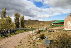
On old Ruta 40 between Perito Moreno and Bajo Caracoles. The "new" Ruta 40 has been rerouted in this area losing a few ups and downs and some curves.
Auf der alten Ruta 40 zwischen Perito Moreno und Bajo Caracoles. Die "neue" Ruta 40 hat eine andere Streckenführung ohne viel Auf und Ab und Kurven.
Cerro FitzRoy/Chaltén
| 24 May 2021 |
|
|
|
Cerro Fitz Roy or Chaltén (Tehuelche for "smoking mountain" because of the frequent clouds) is a 3405m high granite peak in the Southern Patagonian ice field. In the note a wider view from further along the footpath, Piedras Blancas glacier is on the right.
whc.unesco.org/en/list/145
Cerro Fitz Roy oder Chaltén (Tehueche für rauchender Berg wegen der häufigen Wolken) ist ein 3405m hoher Granitgipfel am südlichen patagonischen Eisfeld. Im PiP ein umfassender Blick ein Stück weiter den Wanderweg entlang, rechts der Piedras Blancas Gletscher.
Old Ruta 40
| 23 May 2021 |
|
|
|
Legendary Ruta 40 in all its unsurfaced glory in 2003. These days travel on the surfaced and partially rerouted road is much faster and much more boring....
In the note a Calafate shrub (berberis buxofolia) with berries. It is said if you eat the berries you will return to Patagonia- it's true!
Die berühmte Ruta 40 in all ihrer Pracht im Jahre 2003. Heute ist alles geteert und teilweise begradigt, schneller und viel langweiliger;-) Im PiP ein Calafate-Strauch (berberis buxifolia) mit Beeren. Es heißt, wer von den Beeren isst, wird nach Patagonien zurückkehren. Es ist wahr:-)
Estancia Glencross
| 21 May 2021 |
|
|
|
A scanned slide from Febr 2003. En route to Rio Gallegos on legendary Ruta 40. The PiP shows what's on the other side of the road.
HFF, folks!
Cerro Torre & Cerro Fitz Roy
| 20 Jan 2021 |
|
|
|
A scanned slide from February 2003 when Ruta 23 was still unsurfaced. The typical dust trails were part of the fun;-)
Cerro Torre (3128m) and Cerro Fitz Roy (3405m) are Patagonia's most iconic mountains and among the most difficult to climb (strictly professionals only).
Seeing the top of Torre is a rare treat, usually it's shrouded in clouds creeping in from the Southern Patagonian Icefield.
en.wikipedia.org/wiki/Fitz_Roy
en.wikipedia.org/wiki/Cerro_Torre
Ein Diascan von Februar 2003. Ruta 23 war noch ungeteert, Staubfahnen waren typisch!
Cerro Torre (3128m) und Cerro Fitz Roy (3405m) gehören zu den spektakulärsten Bergen der Welt und sind nur für die besten Bergsteiger machbar, normale Sterbliche bleiben unten:-)
Cerro Torre ist wegen der Nähe zum südlichen patagonischen Eisfeld meist in Wolken gehüllt, wir hatten Glück, ihn frei zu sehen.
whc.unesco.org/en/list/145
Patagonian fence (PiP)
| 17 Nov 2017 |
|
|
|
At the filling station in Bajo Caracoles. There was a strike on and no petrol to be had between there and Calafate;-) Edited for an analogue look.
HFF, folks!
Lago Argentino
Paso Roballos (PiP)
| 12 Aug 2016 |
|
|
|
Paso Roballos is one of the most isolated border crossings between Argentina and Chile, reached by gravel roads from Cochrane through Valle Chacabuco on the Chilean side and from Bajo Caracoles on the Argentinean side. From the Chilean border post- run by Carabineros, not the Policia de Investigacianes as usual- (see first inset) you cross some 10 kms of no man's land before reaching the Argentinean border controls.
Paso Roballos ist einer der abgelegensten Grenzübergänge zwischen Argentinien und Chile, der von beiden Seiten nur über Schotterpisten erreichbar ist, auf chilenischer Seite von Cochrane aus über das Valle Chacabuco und auf argentinischer Seite von Bajo Caracoles aus. Zwischen dem chilenischen Grenzposten (erstes PiP), der anders als üblich nicht von der Policia de Investigaciones, sondern von den Carabineros kontrolliert wird, und dem argentinischen Posten liegen mehr als 10 km Niemandsland.
HHF everybody!
Lago Posadas
| 11 Aug 2016 |
|
|
|
Lago Posadas is a glacial lake in the northern part of Santa Cruz province in Patagonia. It is bordered by glacial moraines and multi coloured volcanic tuffs. Only a narrow isthmus divides it from much larger and deeper Lago Pueyrredón (chil. Lago Cochrane). en.wikipedia.org/wiki/Posadas_Lake
Lago Posadas ist ein türkisfarbener Gletschersee im Norden der argentinischen Provinz Santa Cruz, der von Moränen umgeben ist. Im Osten schließen sich bunte vulkanische Tuffe an. Nach Westen ist der See nur durch einen schmalen Isthmus vom deutlich größeren und tieferen Lago Pueyreddón (in Chile: Lago Cochrane) getrennt.
Crosswind
| 09 Oct 2015 |
|
|
|
Ruta 7 near Esperanza, motorists beware of being blown off the road;-)
HFF everybody!
Ruta 40
| 26 Jul 2015 |
|
|
|
Legendary Ruta 40 is over 5000 km long and traverses Argentina from the Bolivian border to Magellan Strait.
This was taken in good weather between Bajo Caracoles and Tamel Aike, 2 hours later we got into a snowstorm
Hotel Bajo Caracoles
| 25 Jul 2015 |
|
|
|
Bruce Chatwin described Bajo Caracoles as "a crossroads of insignificant importance with roads leading in all directions apparently to nowhere".
The hotel was built in 1943 and also serves as a shop and bar. The name Bajo Caracoles stands for the fossils found there
Bajo Caracoles
| 24 Jul 2015 |
|
|
|
Bajo Caracoles had 33 inhabitants in the 2010 census, a hotel/shop and a filling station. It's an important stop on Ruta 40 because filling stations are far and between.
HFF!
Perito Moreno
| 20 Jan 2015 |
|
|
|
Flowering Notro (Embothrium coccineum) in front of Lago Argentino/Brazo Rico and Perito Moreno Glacier.
Jump to top
RSS feed- Gudrun's latest photos with "Santa Cruz" - Photos
- ipernity © 2007-2025
- Help & Contact
|
Club news
|
About ipernity
|
History |
ipernity Club & Prices |
Guide of good conduct
Donate | Group guidelines | Privacy policy | Terms of use | Statutes | In memoria -
Facebook
Twitter


