Herb Riddle's photos with the keyword: Yewbarrow
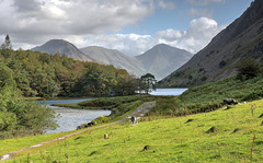
A glimpse of Yewbarrow
| 20 Mar 2021 |
|
|
|
Turning away from Wastwater now, we follow the valley bottom back to our car at Nether Wasdale. The sunshine on the craggy rocks of ‘Hausegreen Crag’ brings out the best of this rugged landscape. Spot the figure. - see PiP
Enjoy full screen.
A first look at WastWater
| 04 Nov 2020 |
|
|
|
As we pass Low Wood on the left we find ourselves at the very southern end of this lonely West Lake District lake, called more correctly a ‘Water’ in common with all but one of the sixteen ‘Lake District’ lakes not being called lakes at all, instead being ‘Meres’ and ‘Waters’. The most prominent hill here is Yewbarrow at 628m resembling the upturned hull of a boat or a barrow.
As usual the landscape is dotted with local sheep. The PiP’s, are taken from the same hillside and possibly in your opinion may have merited having been the main photo here.
Enjoy full screen
Wast Water from the south
| 07 Nov 2020 |
|
|
|
The English Lake District. A view of this wonderful wild lake from the very south west shore. The way around the lake from here is either along a very rough scree path which is slippy and a little dangerous on the right or through the woods on the left (Low Wood) and then along the lakeside path which parallels the minor but sometimes busy road. That is where most of the visitors here walk, us too! We are looking towards Yewbarrow and High Fell. England's highest mountain Scafell Pike sits just out of sight to the right here.
Enjoy full size.
Looking North over Wastwater
| 01 Feb 2021 |
|
|
|
Back to my limited summer of 2020 holidays, here we are at one of Britain's most beautiful lakes. A lake sometimes spoken of as the most mysterious one with a complete side very steep and often dark and dangerous. Its also our deepest lake at 258ft created by glacial erosion. Again we are seeing the impressive Yewbarrow directly in front of us but this time we also see the pointed peak of Great Gables (899 m) looking like a great pyramid.
Enjoy full screen.
Wastwater from the west
| 06 Feb 2021 |
|
|
|
We are now on the tourist route of this lake. Still looking North East and coming across little car parking places on the side of this still narrow road. Just ahead is a very popular picnic area and bathing spot.
A vision of Wastwater
| 07 Feb 2021 |
|
|
|
A view from the western shore picnic area. In warmer weather these rocks are festooned with picnickers. In the water you can see some lively souls having a bit of fun and a dip.
Again we are seeing the impressive Yewbarrow to the left of us and the pointed peak of Great Gables (899 m) looking like a great pyramid directly centre stage. Now we are also starting to see England's highest mountain 'Scafell Pike' at 978 m coming in on the right side.
Enjoy full size.
Yewbarrow. A 'fell' of character.
| 08 Nov 2020 |
|
|
|
A closer look at this impressive fell bordering Wast Water. At 628 metres (just over 2000ft) high and in shape resembling the upturned hull of a boat or a barrow it certainly is impressive, especially looking at it a bit closer as here.
As in most landscape photos, light is essential in bringing out the form and displaying each cliff and crag. We can also discern bracken. This is a favourite tough climb with steep crags at either end providing a good challenge for most walkers.
Geoogy: The summit is formed from the tuff, lapilli-tuff and breccia of the Lingmell Formation. The eastern slopes display the rhyolitic rocks of the Long Top Member and Crinkle Member. The crags on the western face are outcrops of the plagioclase-phyric andesite lavas of the Birker Fell Formation. (Wiki)
Enjoy full screen
Jump to top
RSS feed- Herb Riddle's latest photos with "Yewbarrow" - Photos
- ipernity © 2007-2025
- Help & Contact
|
Club news
|
About ipernity
|
History |
ipernity Club & Prices |
Guide of good conduct
Donate | Group guidelines | Privacy policy | Terms of use | Statutes | In memoria -
Facebook
Twitter


