Weather and skyscapes
Folder: Nature
02 Mar 2022
25 favorites
19 comments
It's arrived
For most of the past week, the central coast of eastern Australia, IE southeast Queensland and northern NSW, have been experiencing a massive and very unusual rainfall event. An upper low pressure system over the area has been fed with a stream of very moist tropical maritime air by a high pressure system near New Zealand. Although this sub-tropical area normally has a summer rainfall peak, the amounts from this system are far outside the usual bounds. Falls of 200mm daily with over a metre in the week have been common, with even over 700mm in 24 hours in some spots. ( ADDITION: I've just read that the top 1 week rainfall was about 1.8 M.) Needless to say, this has caused massive flooding and disruption in many areas.
The weather system is now moving southwards, bringing the high rainfalls to Sydney and to my location further south. It should dissipate in the next few days, but not before causing further problems.
This event is well outside what would be considered "normal", but it's entirely in keeping with the latest IPCC report issued on 28 February 2022. The media release with it warns “This report recognizes the interdependence of climate, biodiversity and people and integrates natural, social and economic sciences more strongly than earlier IPCC assessments, ....It emphasizes the urgency of immediate and more ambitious action to address climate risks. Half measures are no longer an option.”
Hobart sunrise
Needs to be viewed large on black. Showing the port area of Hobart viewed from the hotel room, at sunrise on the day of my departure from Hobart. A stitched panorama.
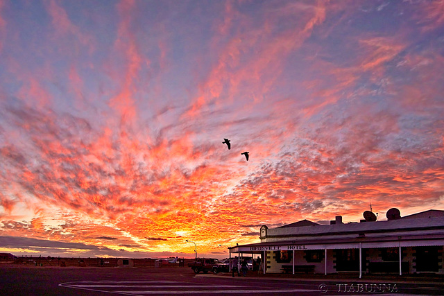
Birdsville Sunset
A real bonus when these two birds came past this sunset. :-) Click the PiP to enter the pub's main bar.
I shall be away and offline for several days. Best wishes, everyone
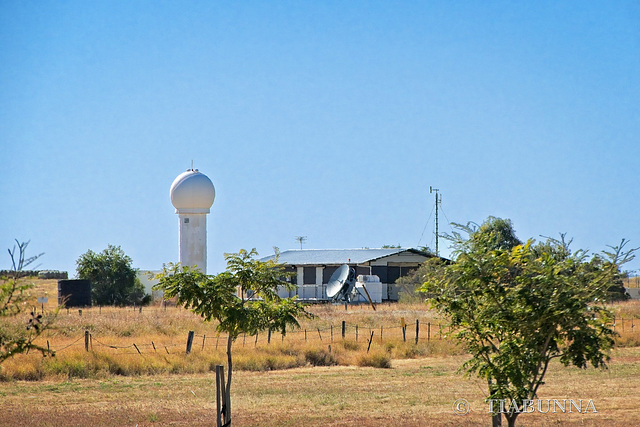
Weather office
This would have been the Longreach weatther office. Like most such field offices I'm fairly sure it now is deserted and automated, though the Dines Anemometer still is there at right. In the foreground (that dish mounted on a turret) an old WF2 wind-finding radar, as I used to operate long ago. It's now very much a museum piece. Behind, to the left, is the current Longreach weather radar, you can see its current output here.
Footnote: If you'd like to see the current Longreach weather, click the little box at lower right in the "map features" section of the radar page. The red number is temperature, blue is wind speed.
Reposted to wish everyone a HFF and a great weekend.
WF2 radar
Copied from an old 1965 slide. This WF2 (WF short for Wind Finding) radar was in a suburb of Melbourne not far from Essendon Airport. It was used to train people such as me and had a range of 200km. I find myself thinking how inappropriate it would now be considered to have such a potentially dangerous beast so close to houses, with just a fence (seen best viewed large) between. In the PiP, a weather balloon launched from the same site, with (from the top) the 350gm balloon, a parachute, the radar reflector and the radiosonde to send back atmospheric data.
Happy Fence Friday and have a good weekend, everyone.
13 May 2024
20 favorites
12 comments
Big rain
I've just returned from my travels today and this was my rain gauge on returning. In just over a week, there was 255 mm (10 inches) of rain. This was way outside normal weather patterns - a new monthly record in less than half a month! It also matches the record rain and flood events being seen worldwide and consistent with climate change.
Sunset storm
These passing cumulonimbus clouds with the typical anvil shape were, from the weather radar, about 40 km distant from me. A short thunderstorm for some. Best viewed large.
Jump to top
RSS feed- Latest items - Subscribe to the latest items added to this album
- ipernity © 2007-2025
- Help & Contact
|
Club news
|
About ipernity
|
History |
ipernity Club & Prices |
Guide of good conduct
Donate | Group guidelines | Privacy policy | Terms of use | Statutes | In memoria -
Facebook
Twitter


