Berny's photos
Dique Punta Negra
| |
|
Von Giuliano gb - Eigenes Werk, CC BY-SA 4.0, commons.wikimedia.org/w/index.php?curid=47967812
Rio San Juan - Ruta 12
| |
|
|
|
The next trip section is the old road "Ruta 12" along the valley of Rio San Juan. It was an adventurous road back then. Now the valley has changed a lot, because several large reservoirs were constructed and the road is a dead end from both sides, it is under water for several parts. In this image construction works begin in 2000 for the dam "Dique Punta Negra", the largest of the reservoirs. - scanned slide, Minolta X700
The PiP shows the actual situation, the dam is 118 m high, the reservoir has a volume of 500 Mio. m³ (photo by Giuliano gb - Eigenes Werk, CC BY-SA 4.0, commons.wikimedia.org/w/index.php?curid=47967812):
Ischigualasto - leaving on Ruta Provincial 259
Ischigualasto - Cerro Merado 1768 m
Ischigualasto - red walls
Ischigualasto - red walls
Ischigualasto - El Hongo
| |
|
|
|
"El Hongo" means mushroom (Pilz) - Ischigualasto, San Juan, Argentina.
scanned slide, Minolta X700
Ischigualasto - El Hongo
| |
|
Ischigualasto - El Submarino
Ischigualasto - El Submarino
Ischigualasto - desert
Zonda wineland - HFF!
| |
|
|
|
HFF and a sunny weekend everyone!
Vineyard near the village Zonda, province San Juan. Argentina.
scanned slide, Minolta X700
Ischigualasto - El Submarino
| |
|
|
|
This rock was easier to climb than the submarine itself ;-)
scanned slide, Minolta X700
Ischigualasto - El Submarino
| |
|
|
|
The submarine from another angle, and as overlook in the PiP. - scanned slide, Minolta X700
Ischigualasto - El Submarino overlook
Ischigualasto - El Submarino
| |
|
|
|
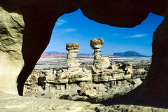
The formation is called "The Submarine", seen here through a rock window. Unfortunately the left of the two "towers" collapsed in the meantime. So this view doesn't exist anymore. - scanned slide, Minolta X700
Valley Of The Moon
| |
|
|
|
Ischigualasto - no green, except in the first PiP ;-)
scanned slide, Minolta X700


