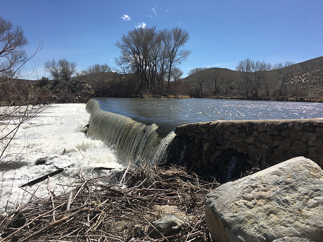
Diversion weir for Mexican Ditch
It's OK; they are not pets ...
Hoover Dam
Big Girls at the Fair (2)
Big Girls at the Fair (1)
Aftermath
Shoshone Falls
Healing
I.B. Perrine Bridge
Little Girls at the Fair (3)
Chicago City Fog
Monkey Face
Fiord Wall Reflections
BP - 29
Alaska
Rescue Me!
Bryce Canyon USA
New moon, Old Glory
The Capitol (Explored)
Valley of fire (Nevada)
Notch Peak
Hercules Gap
Northern Oregon
Waterfall, Big Box Canyon
Big Box Canyon
Heads and Hooves
Florets Waiting to Pop ...
American Dogwood
Morning Dog Walk - City of Chicago
Berserk BlueBerry Baker
Flood in Light and Dark
Floodwaters Pound the Rocks
USA - Arizona, Grand Canyon National Park
Down The Road -
A Glimmer of Life for the Old Railway Station ...
USA - Utah, Capitol Reef National Park
A Day for those who - Look Up !
Kayak Repair
Signs of Spring 2.0
Grand Teton National Park
Road to Shoshone Pass
California tree
Eisenbahn-Bau
railway construction
Dixie Valley
Location
Lat, Lng:
You can copy the above to your favourite mapping app.
Address: unknown
You can copy the above to your favourite mapping app.
Address: unknown
See also...
Keywords
Authorizations, license
-
Visible by: Everyone -
All rights reserved
-
566 visits
Diversion weir for Mexican Ditch


On the Carson River outside Carson City, Nevada, in Silver Saddle Ranch park. Mexican Ditch was built ca. 1860 to provide water for a mill that was processing ore from the Comstock Lode in Virginia City. Water from the ditch was also promptly diverted for agriculture as well, which led to litigation (and some violence) between the miners and the farmers. The issue was resolved in favor of the miners, which turned out to be a Pyrrhic victory as the mill had shut down by 1907. The left inset shows the headgate that lets water into the ditch. The right inset shows more or less this same view in Sept. 2012, at the height of the drought, when the river was virtually dry.
Why "Mexican" Ditch? This area had been under Mexican sovereignty not long before the Comstock was discovered, having been transferred to US control by the Treaty of Guadalupe Hidalgo in 1848. I suspect there were a number of Mexicans living in the area who suddenly found themselves under US jurisdiction, and they may well have provided much of the labor.
"Whiskey's for drinking. Water's for fighting over." -- Mark Twain
Frans Schols, Smiley Derleth, Trudy Tuinstra, tiabunna and 2 other people have particularly liked this photo
- Keyboard shortcuts:
Jump to top
RSS feed- Latest comments - Subscribe to the comment feeds of this photo
- ipernity © 2007-2025
- Help & Contact
|
Club news
|
About ipernity
|
History |
ipernity Club & Prices |
Guide of good conduct
Donate | Group guidelines | Privacy policy | Terms of use | Statutes | In memoria -
Facebook
Twitter

Admired in:
www.ipernity.com/group/tolerance
Sign-in to write a comment.