On test server

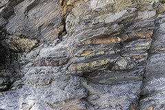
Extentional faults detail: Saundersfoot south
Ladies Cave Anticline
Ladies Cave Anticline: interior hinge zone
Asymmetric anticline, Swallowtree Bay north
Syncline in Lower Coal Measures sandstones: Swallo…
Swallowtree Bay anticline-syncline couplet
Swallowtree Bay anticline-syncline couplet: detail…
Swallowtree Bay anticline-syncline couplet: detail…
Swallowtree Bay anticline-syncline couplet: detail…
Swallowtree Bay anticline-syncline couplet: detail…
Swallowtree Bay anticline-syncline couplet: detail…
Swallowtree Bay anticline-syncline couplet: detail…
Swallowtree Bay anticline-syncline couplet: detail…
Swallowtree Bay anticline-syncline couplet: detail…
Swallowtree Bay anticline-syncline couplet: detail…
Hornet hoverfly - Volucella zonaria
River Porter waterfall (1)
River Porter waterfall (2)
River Porter waterfall (3)
River Porter waterfall (4)
River Porter waterfall (5)
River Porter waterfall in spate: video clip
Hogweed seed heads
Small thrust and footwall syncline
Lattice Windows sea arches and Barafundle Bay
Barafundle Bay cloudscape from Stackpole Head
Stackpole Head from Mowingword Point
Lichens and Viper's Bugloss on Mowingword Point
Mowingword Bay, Pinnacle Stack and Gun Cliff
Sandy Pit doline panorama
Sandy Pit doline
Box Bay panorama
Box Bay with caves
Church Rock from Saddle Point
Broad Haven (S) view west
Broad Haven (S) view east to Stackpole Head and Ca…
Gateholm and Skokholm Islands
Victoria Bay bedding planes in Silurian sandstones
Victoria Bay and Skokholm Island
St Brides Haven - view east
St Brides Haven: colourful rocks, colourful sea
St Brides Haven solifluction deposit
Druidston Haven: Cliff Section 1 interpretation
Druidston Haven: Cliff Section 1 panorama
Druidston Haven: Cliff Section 2 interpretation
1/125 • f/6.3 • 21.0 mm • ISO 400 •
Canon EOS 600D
EF-S15-85mm f/3.5-5.6 IS USM
Location
Lat, Lng:
You can copy the above to your favourite mapping app.
Address: unknown
You can copy the above to your favourite mapping app.
Address: unknown
See also...
Keywords
Authorizations, license
-
Visible by: Everyone -
All rights reserved
-
206 visits
Extentional faults: Saundersfoot south


Saundersfoot to Swallowtree Bay geological structures
Just south of Saundersfoot harbour, immediately adjacent to the previous photo, a set of extensional ('normal') faults with a small displacements cut Lower Coal Measures rocks: mostly mudstones with ironstone bands and nodules, with thin sandstone bands and laminae in the upper part.
The small thrust with a footwall syncline in the previous photo is just visible at the lower right.
The walking stick is 0.9 m long.
Detailed part of photo here:
- Keyboard shortcuts:
Jump to top
RSS feed- Latest comments - Subscribe to the comment feeds of this photo
- ipernity © 2007-2025
- Help & Contact
|
Club news
|
About ipernity
|
History |
ipernity Club & Prices |
Guide of good conduct
Donate | Group guidelines | Privacy policy | Terms of use | Statutes | In memoria -
Facebook
Twitter
Sign-in to write a comment.