Coastal
Photos taken at or near the coast.
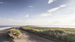
Spurn north end view SW over the Spurn Neck
| |
|
|
|
A visit to Spurn Point 26
Looking south-west from the landward end of Spurn, over the narrow Spurn Neck (the high spring tide wash-over zone). Spurn Point itself, and the two lighthouses, are visible on the skyline towards the right.
Spurn east beach bank, swales and ripples 2
| |
|
|
|
A visit to Spurn Point 25
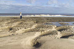
Sand and gravel bars (possibly with a foundation of the Wolstonian age Basement Till) parallel to the coast allow the formation of elongate tidal pools, which become completely flooded by the incoming tide.
In this view the darker clayey gravel bar is in the middle distance on the left. In the foreground are large, metre-scale linguoid ripples: 'swales'. These are highly asymmetrical, with the steep lee sides facing south, indicating a predominant current direction from north to south (left to right). This is consistent with the southward longshore drift along the east of England coast
The linguoid swales in turn display centimetre-scale sand ripples on the stoss slopes. The ripples tend to be more symmetrical, indicating a current direction alternating between northward (to the left) flow on the flooding tide and southward flow (to the right) when the tide is ebbing.
In this photo the incoming tide is just beginning to flood the low swale zone.
Spurn east beach bank, swales and ripples 1
| |
|
|
|
A visit to Spurn Point 24
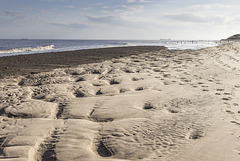
Sand and gravel bars (possibly with a foundation of the Wolstonian age Basement Till) parallel to the coast allow the formation of elongate tidal pools, which become completely flooded by the incoming tide.
In this view the darker clayey gravel bar is in the middle distance. In the foreground are large, metre-scale linguoid ripples: 'swales'. These are highly asymmetrical, with the steep lee sides facing south, indicating a predominant current direction from north to south (left to right). This is consistent with the southward longshore drift along the east of England coast
The linguoid swales in turn display centimetre-scale sand ripples on the stoss slopes. The ripples tend to be more symmetrical, indicating a current direction alternating between northward (to the left) flow on the flooding tide and southward flow (to the right) when the tide is ebbing.
Spurn Warren view E to wind farm
| |
|
|
|
A visit to Spurn Point 23
A view east from Spurn Warren, with the Humber Gateway Offshore Wind Farm visible on the horizon.
Spurn lighthouses view NE
| |
|
|
|
A visit to Spurn Point 22
There are two lighthouses on Spurn; the newer 'High Lighthouse', painted black and white, was built 1893-95; the older 'Low Lighthouse' is visible on the left.
The Lower Lighthouse', was built by engineer John Smeaton and completed in 1776. But by 1892, the structure was becoming cracked and unstable, and the new 'Upper Lighthouse' was constructed to replace Smeaton's light.
The black cylinder on the top of the Lower Lighthouse is a water tank, which has replaced the former lantern turret.
Spurn Lower Lighthouse
| |
|
|
A visit to Spurn Point 21
There are two lighthouses on Spurn; this is the older, 'Lower Lighthouse', which was built by engineer John Smeaton and completed in 1776.
By 1892, the structure was becoming cracked and unstable, and the new 'Upper Lighthouse' was constructed to replace Smeaton's light.
The black cylinder on the top is a water tank, which has replaced the former lantern turret.
Spurn High Lighthouse 3
| |
|
|
A visit to Spurn Point 20
There are two lighthouses on Spurn; this is the lantern turret of the newer 'High Lighthouse', which was built 1893-95.
More details here:
historicengland.org.uk/listing/the-list/list-entry/1083476
The High Lighthouse was taken out of service in 1985 and is now managed and opened for visitors by the Yorkshire Wildlife Trust.
Spurn High Lighthouse 2
| |
|
|
A visit to Spurn Point 19
There are two lighthouses on Spurn; this is the newer 'High Lighthouse', which was built 1893-95.
More details here:
historicengland.org.uk/listing/the-list/list-entry/1083476
The High Lighthouse was taken out of service in 1985 and is now managed and opened for visitors by the Yorkshire Wildlife Trust.
Spurn High Lighthouse 1
| |
|
|
A visit to Spurn Point 18
There are two lighthouses on Spurn; the newer 'High Lighthouse', painted black and white, was built 1893-95; the older 'Low Lighthouse' is visible to the right of centre.
More details here:
historicengland.org.uk/listing/the-list/list-entry/1083476
The High Lighthouse was taken out of service in 1985 and is now managed and opened for visitors by the Yorkshire Wildlife Trust.
Spurn Warren view NE
| |
|
|
A visit to Spurn Point 17
A view north-east from Spurn Warren, with the Humber Gateway Offshore Wind Farm just visible on the horizon.
Spurn Warren view W to Grimsby
| |
|
A visit to Spurn Point 16
This is a view from the grassy sand bank of Spurn Warren across the Humber Estuary to Grimsby with its prominent Dock Tower.
Spurn Warren view SW to lighthouses
| |
|
|
A visit to Spurn Point 15
The southern part of Spurn widens into the grassy sand banks of Spurn Warren. There are two lighthouses on Spurn; the newer 'High Lighthouse', painted black and white, was built 1893-95; the older 'Low Lighthouse' is visible to the right of centre.
More details here:
historicengland.org.uk/listing/the-list/list-entry/1083476
The High Lighthouse was taken out of service in 1985 and is now managed and opened for visitors by the Yorkshire Wildlife Trust.
Spurn Warren view NE
| |
|
|
|
A visit to Spurn Point 14
A view north-east from the grassy sand banks of Spurn Warren.
Spurn Chalk Bank view WNW to Immingham
| |
|
A visit to Spurn Point 13
The western side of Spurn overlooks the salt marsh and mud flats: a haven for wading and migrating birds, which flock here to feed.
On the far side of the Humber Estuary are the industrial complexes and refineries between Grimsby and Immingham docks.
Spurn Chalk Bank view north 2
| |
|
A visit to Spurn Point 12
The western side of Spurn overlooks the salt marsh and mud flats: a haven for wading and migrating birds, which flock here to feed.
The white Chalk boulders originate from barge-loads of Chalk emplaced on the west side of the spit during the period 1851 - 1857 following a series of storm surge breaches.
Spurn Chalk Bank view north 1
| |
|
A visit to Spurn Point 11
The western side of Spurn overlooks the salt marsh and mud flats: a haven for wading and migrating birds, which flock here to feed.
The white Chalk boulders originate from barge-loads of Chalk emplaced on the west side of the spit during the period 1851 - 1857 following a series of storm surge breaches.
Spurn groyne and large vessel
| |
|
|
A visit to Spurn Point 10
The east-facing beach of Spurn has a series of groynes, now mostly in disrepair. The object was presumably to try to limit sediment drift southwards to help keep the mouth of the Humber clear for shipping.
A large cargo vessel is moored in the estuary mouth, perhaps awaiting high tide before moving off?
Spurn groyne 3
| |
|
A visit to Spurn Point 9
The east-facing beach of Spurn has a series of groynes, now mostly in disrepair. The object was presumably to try to limit sediment drift southwards to help keep the mouth of the Humber clear for shipping.
Jump to top
RSS feed- Latest items - Subscribe to the latest items added to this album
- ipernity © 2007-2025
- Help & Contact
|
Club news
|
About ipernity
|
History |
ipernity Club & Prices |
Guide of good conduct
Donate | Group guidelines | Privacy policy | Terms of use | Statutes | In memoria -
Facebook
Twitter


