tiabunna's photos with the keyword: north
Stockmen mustering
| 06 Apr 2024 |
|
|
|
From an old slide taken in 1971. Heading up the Oodnadatta Track we met this group of stockmen going out (with their spare horses) to commence mustering (possibly several weeks) on Anna Creek Station. Anna Creek (23,677 km2 (9,142 sq mi) is the world's largest cattle station, 7 times larger than the largest US ranch and larger than countries such as Slovenia and Israel. The number of cattle varies with the conditions (drought etc) but typically is between 10-20,000.
As this work is now mechanised with aircraft and motorcycles, this has become a historic image!
Translations to US English: stockmen = cowboys, station = ranch, mustering = rounding up.
The wind picked up
| 09 Sep 2019 |
|
|
|
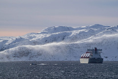
Some wind picked up as we headed toward Hammerfest, lifting drifting snow from the hillsides. Another LNG tanker at right.
Explored.
The mast
| 22 Aug 2019 |
|
|
|
Directly in the light of the rising sun, a mast is visible near the horizon. I'll admit that it looks pretty much like any other mast, but for me it was one of the highlights of our trip. "Why?" I hear you ask. It was from that mast, in 1926, that the airship Norge departed to make the first ever aircraft flight to the North Pole and also the first flight over the ice cap between Europe and North America. Best viewed large.
Fenced fish farms in the foreground - Norway seems to have fish farms everywhere! HFF and have a great weekend, everyone.
My involvement on ipernity is limited at present, so my apologies if I do not respond to your comments or visit your images - I shall try to do so as far as possible.
After Tromso
| 18 Aug 2019 |
|
|
|
I won't even try to place this on the map, except to say that it was taken between Tromso and Honningsvag. Right along the Norwegian coast, it was surprising to see little cottages sprinkled along what would have seemed totally isolated shorelines. Best viewed large.
My involvement on ipernity is limited at present, so my apologies if I do not respond to your comments or visit your images - I shall try to do so as far as possible.
Explored.
The northern cliffs
| 23 May 2017 |
|
|
|
The northern end of Lord Howe Island is fronted by cliffs over 200 metres high. (Second image in note).
The bird catchers
| 01 Feb 2017 |
|
|
|
These men in the village of Xay Oudom were repairing a weighted net used to catch birds. It's a subsistence lifestyle in the highland villages of Laos. See the note to meet some of the village women. Well, this seems an appropriate musical link.
Hill village women
| 01 Feb 2017 |
|
|
|
Watching and having a laugh as the tourists go wandering through the village of Xay Oudom (street scene in previous image). Image of some of the men in a note.
Mannahill Creek
| 01 Aug 2014 |
|
|
|
Best viewed on black. In the 1880s, the Broken Hill Proprietary Company (usually now known just as BHP) built a railway from their mine at Broken Hill to their smelter and port at Port Pirie. Mannahill is somewhere along the rail line (and now also a road). This is the creek in the area: those are ghost gums alongside the watercourse, with saltbush beyond.
Macquarie Island 1968: Toward the station from the…
| 23 Jan 2013 |
|
|
From an old slide: the move to Flickr has done something strange to the clouds. Penguins at right foreground beach. Best viewed on black.
Panorama of Macquarie Island, looking south from N…
| 14 Sep 2016 |
|
|
|
After several years of mixed intentions, I understand that there are now (2023) plans to rebuild the existing station.
Panorama stitched from three film slides, looking south across the station and isthmus toward the main part of the island. (It is about 35km long and 5km wide). Partly because the old Kodachrome film was low ISO, most photos were taken on sunny "Kodachrome" days - sadly that is not representative of the usual weather. Macquarie has about 350 days yearly on which it rains (or drizzles), it is usually overcast, and often foggy. Strong winds, usually from the west, are almost constant.
Best viewed large.
Jump to top
RSS feed- tiabunna's latest photos with "north" - Photos
- ipernity © 2007-2025
- Help & Contact
|
Club news
|
About ipernity
|
History |
ipernity Club & Prices |
Guide of good conduct
Donate | Group guidelines | Privacy policy | Terms of use | Statutes | In memoria -
Facebook
Twitter


