Joel Dinda's photos with the keyword: view
Arcadia Lookout
| 02 Nov 2014 |
|
I've been playing with DxO's OpticsPro photo processing software all afternoon. Thought I'd share a few examples.
One of the features DxO is advertising for the 10th version of OpticsPro is a technology they call ClearView , a haze removal tool. This is a test: Compare a version I posted of this photo a few years back , processed using Photoshop Elements. The new version's better.
North from Sleeping Bear
| 02 Nov 2014 |
|
|
|
I've been playing with DxO's OpticsPro photo processing software all afternoon. Thought I'd share a few examples.
Another photo from the same vacation, again testing the OpticsPro's ClearView feature. It seems to work, even on a JPG original.
Gorge
| 13 Jan 2011 |
|
Taken at West Virginia's Babcock State Park with my Nikon N90s in late September of 1999. Compare this photo Joan took last summer from a nearby location. We're looking down the Manns Creek Gorge toward the New River. After a severe downhill run, Manns Creek joins the New at what used to be Sewell, where I'm told there are ruins of coking ovens.
I've complained from time to time about the high-speed film I've been scanning from my photo collection, but that's a little misleading. My pattern, historically, was to pick a specific film each year and shoot almost exclusively using that product until the next year. This means that I've made photographs with all sorts of films--so the scanning problems I've had of late were largely because I've been choosing to scan years with difficult films. This photo, in contrast, came out very nicely.
Mineview in the Sky
| 18 Dec 2005 |
|
My family--Mom (Hatti), Debbie, Joan, and (mostly hidden) Richard. High in the sky above Virginia, Minnesota. August, 1996. Fine photo of Debbie & Mom. If only I could do something about the danged fence....
Camera: Chinon Genesis III
Saint Ignace
Thornapple Valley
| 11 Dec 2013 |
|
|
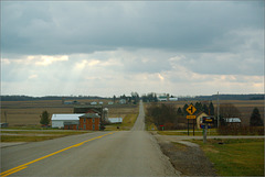
When you reach the east end of Needmore Highway you likely turn south, and are rewarded with this view.
This was generally the highlight of my drive to work, but I'd admired the view long before I moved to Mulliken. A couple miles out--just beyond the more distant farmyards--Otto Road dips yet again, down to the river. When I was a serious bicyclist my most strenuous workouts involved those climbs. Nowadays I mostly avoid hills, which is pretty easy around here.
You could turn north, but Otto and Needmore both jog, and the left turn's a bit off the line. A north turn takes you to the RC plane airport .
==========
The 366 Snaps pix were attempts to capture the falling snow in an image; most failed.
==========
This photograph is a non-outtake from my 2012 photo-a-day project, 366 Snaps .
Number of project photos taken: 19
Title of " roll :" Snow in the Banana Republic [ a comment on Michigan's then-newly-signed "RTW" law, about which I'm still angry ]
Other photos taken on 12/11/2012: Two "Sky Shots," one of which is displayed above.
Jump to top
RSS feed- Joel Dinda's latest photos with "view" - Photos
- ipernity © 2007-2025
- Help & Contact
|
Club news
|
About ipernity
|
History |
ipernity Club & Prices |
Guide of good conduct
Donate | Group guidelines | Privacy policy | Terms of use | Statutes | In memoria -
Facebook
Twitter


