Earthwatcher's photos with the keyword: erosion
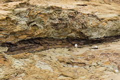
Benacre cliffs: Norwich Crag cross-bedding detail
| 28 Jul 2015 |
|
Close-up view of cross-bedded sands and gravels of the Norwich Crag (early Pleistocene) at Benacre Cliffs, just north of Covehithe in Suffolk.
Height of section: approx. 1.3 metres. Full view of cliff here:
www.ipernity.com/doc/earthwatcher/39078910
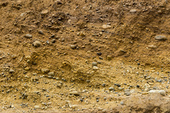
Benacre cliffs - Norwich Crag cross-bedded sands
| 28 Jul 2015 |
|
Cross-bedded sands and gravels of the Norwich Crag (early Pleistocene) at Benacre Cliffs, just north of Covehithe in Suffolk.
This stretch of coast line is currently experiencing the most active coastal erosion in the UK, with average loss rates of around 7 metres per year. The cliffs are only recently formed and are growing in height. The land behind the cliff line is a gentle hill, therefore as the sea eats into the cliff line causing it to retreat westwards into the hillside, so the top of the cliff gets higher.
Benacre Cliffs - Norwich Crag bioturbated clay wit…
| 28 Jul 2015 |
|
Benacre Cliffs, just north of Covehithe in Suffolk, are comprised of cross-bedded sands and gravels of the Westleton Formation, with beds of bioturbated clay; part of the Norwich Crag, early Pleistocene in age. Here, a fossil tree branch can be seen in the clay. 20p coin for a scale.
Benacre Cliffs cross-bedded gravels 1
| 28 Jul 2015 |
|
Detail of cross-bedded sands and gravels of the Westleton Formation; part of the Norwich Crag (early Pleistocene) at Benacre Cliffs, just north of Covehithe in Suffolk.
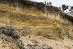
Benacre Cliffs - Westleton Formation
| 28 Jul 2015 |
|
Benacre Cliffs, just north of Covehithe in Suffolk, are comprised of cross-bedded sands and gravels of the Westleton Formation, with beds of bioturbated clay; part of the Norwich Crag, early Pleistocene in age.
This stretch of coast line is currently experiencing the most active coastal erosion in the UK, with average loss rates of around 7 metres per year. The cliffs are only recently formed and are growing in height. The land behind the cliff line is a gentle hill, therefore as the sea eats into the cliff line causing it to retreat westwards into the hillside, so the top of the cliff gets higher.
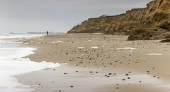
Looking towards Southwold from Benacre Cliffs
| 28 Jul 2015 |
|
Benacre Cliffs, just north of Covehithe in Suffolk, are comprised of cross-bedded sands and gravels of the Westleton Formation, with beds of bioturbated clay; part of the Norwich Crag, early Pleistocene in age.
This stretch of coast line is currently experiencing the most active coastal erosion in the UK, with average loss rates of around 7 metres per year. The cliffs are only recently formed and are growing in height. The land behind the cliff line is a gentle hill, therefore as the sea eats into the cliff line causing it to retreat westwards into the hillside, so the top of the cliff gets higher.
Collapsed pill box at Benacre Cliffs
| 28 Jul 2015 |
|
Benacre Cliffs, just north of Covehithe in Suffolk, are comprised of cross-bedded sands and gravels of the Westleton Formation, with beds of bioturbated clay; part of the Norwich Crag, early Pleistocene in age.
This stretch of coast line is currently experiencing the most active coastal erosion in the UK, with average loss rates of around 7 metres per year. The cliffs are only recently formed and are growing in height. The land behind the cliff line is a gentle hill, therefore as the sea eats into the cliff line causing it to retreat westwards into the hillside, so the top of the cliff gets higher. The collapsed WW2 pill-box illustrates the erosion process.
Benacre Silver Birch
| 28 Jul 2015 |
|
Benacre cliffs in north Suffolk is an area of active coastal erosion (up to 7 metres per year) and currently the highest rate of retreat in the UK.
At this point, just north of the now-breached Benacre Broad, the beach is littered with the remains of trees as a result of the undercutting and erosion of the cliffs and land on which they were growing.
Benacre Silver Birch (BW)
| 28 Jul 2015 |
|
Benacre cliffs in north Suffolk is an area of active coastal erosion (up to 7 metres per year) and currently the highest rate of retreat in the UK.
At this point, just north of the now-breached Benacre Broad, the beach is littered with the remains of trees as a result of the undercutting and erosion of the cliffs and land on which they were growing.
I think the grainy black and white treatment suits the subject well...
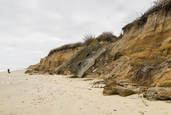
Norwich Crag at Benacre cliffs
| 28 Jul 2015 |
|
Benacre Cliffs, just north of Covehithe in Suffolk, are comprised of sands and gravels of the Westleton Formation, with beds of bioturbated clay; part of the Norwich Crag, early Pleistocene in age.
This stretch of coast line is currently experiencing the most active coastal erosion in the UK, with average loss rates of around 7 metres per year. The cliffs are only recently formed and are growing in height. The land behind the cliff line is a gentle hill, therefore as the sea eats into the cliff line causing it to retreat westwards into the hillside, so the top of the cliff gets higher.
Benacre Broad at low tide
| 28 Jul 2015 |
|
Benacre Broad National Nature Reserve adjacent to the coast in north Suffolk was previously a brackish water lake separated from the North Sea by a narrow barrier of sand and shingle. Now the barrier has been once again breached by the sea, it is a salt-water lake. This is in an area of active coastal erosion (up to 7 metres per year) and currently the highest rate of retreat in the UK.
Benacre Broad breach channel to the North Sea
| 28 Jul 2015 |
|
Benacre Broad National Nature Reserve adjacent to the coast in north Suffolk was previously a brackish water lake separated from the North Sea by a narrow barrier of sand and shingle. Now the barrier has been once again breached by the sea, it is a salt-water lake. This is in an area of active coastal erosion (up to 7 metres per year) and currently the highest rate of retreat in the UK.
Benacre Broad and breach channel
| 28 Jul 2015 |
|
Benacre Broad National Nature Reserve adjacent to the coast in north Suffolk was previously a brackish water lake separated from the North Sea by a narrow barrier of sand and shingle. Now the barrier has been once again breached by the sea, it is a salt-water lake. This is in an area of active coastal erosion (up to 7 metres per year) and currently the highest rate of retreat in the UK.
Narrowing the field - very recent coastal erosion…
| 27 Feb 2011 |
|
|
Average coastal erosion rates for this part of the Holderness coast are in excess of 2.5 metres per year but sometimes a great chunk will go all at once. The main mechanism for the erosion is failure and collapse of the Skipsea Till (grey/brown in the photo) by rotational landslides. The slipped material is readily removed by the sea during storms and high tides, exposing a fresh cliff face which rapidly becomes unstable, eventually failing once more.
Coastal erosion near Skipsea, East Yorkshire.
| 03 Mar 2011 |
|
The cliffs in this section of the Holderness coast are comprised of the Skipsea Till (Devensian) Rotational landslides cause active retreat of the cliff line on average in excess of 2.5 metres per year.
Danger - Coastal Erosion
| 27 Feb 2011 |
|
Recent coastal erosion near Skipsea, East Yorkshire
There were huts and shacks on the seaward side of the track until recently. At March 2011 Google Maps still show them.
Skipsea Withow Mere, Holderness coast, East Yorksh…
| 16 Feb 2009 |
|
Originanally uploaded for the Guesswhere UK group.
A rather old photo taken with an early digital camera, hence rather poor resolution.
This is the Skipsea Withow Mere and the location is the Withow Gap on the Holderness coast in East Yorkshire. The rapidly eroding low cliffs have cut a section through the Withow Mere which is a former (post glacial) lake formed in an ice-hollow on the till ('boulder clay') surface. The lake became filled with both drifted and in-situ vegetation which accounts for the peat we see today.
The grey pebbly deposit in the foreground is the Skipsea Till, a 'boulder clay' of debris bulldozed by the Devensian ice. Were it not for the glacial till, the area of Holderness would not exist and would be completely under the sea.
The Skipsea Withow Mere is a SSSI.
More information here:
www.york.ac.uk/inst/chumpal/EAU-reps/EAU94-61.pdf
Peat section in the Skipsea Withow Mere, Holdernes…
| 16 Feb 2009 |
|
Uploaded as a clue to the GWUK photo here....
www.ipernity.com/doc/earthwatcher/39023396
Jump to top
RSS feed- Earthwatcher's latest photos with "erosion" - Photos
- ipernity © 2007-2025
- Help & Contact
|
Club news
|
About ipernity
|
History |
ipernity Club & Prices |
Guide of good conduct
Donate | Group guidelines | Privacy policy | Terms of use | Statutes | In memoria -
Facebook
Twitter


