Earthwatcher's photos with the keyword: geological interpretation
Little Haven - The Settlands panorama - geological…
| 02 Apr 2019 |
|
Structural geology of Little Haven and The Settlands
The cliffs from Little Haven to Broad Haven (and northward) display a spectacular range of geological structures, folding, faulting and thrusting, mainly in the Lower Coal Measures. The relatively weak mudstone and shale-dominated sequences show much incompetent deformation: tight, thrusted and overturned folds, in contrast to the thicker, stronger, sandstones which have formed relatively open and concentric folds.
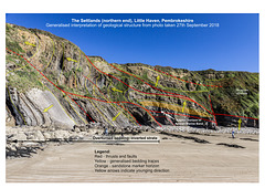
The cliffs at the east end of the The Settlands bay display a series of complexly thrusted, folded and faulted Lower Coal Measures rocks. The folds are overturned to the north, becoming nearly recumbent (low-angle fold axes) near the northern headland, known as 'The Rain'. The complexity of the folding is mostly due to the predominance of weak mudstones and shales which undergo incompetent deformation, in contrast to the open folding in the strong sandstone Fox Hole anticline in previous photos.
This is a generalised geological interpretation of the visible structures in the previous photo:
www.ipernity.com/doc/earthwatcher/49995364
There are two main thrusts and several smaller thrust splays which result in repetition of the strata, mainly around the horizon of the Amman Marine Band. The weaker mud-rich rocks have deformed and thickened into the axial crests of the folds and usually display a degree of axial planar cleavage. The folds are mainly overturned anticlines; the synclines have been cut out by thrusting. The small anticline visible on the right may possibly be comprised of the uppermost beds of the Fox Hole sandstone, but the correlation is very uncertain.
See notes for links to detailed views.
The background photo is a panoramic view consisting of three landscape photos stiched together in Affinity Photo sofware. Interpretation linework carried out using Affinity Designer software.
Little Haven - The Settlands; recumbent fold, thru…
| 02 Apr 2019 |
|
|
Structural geology of Little Haven and The Settlands
The cliffs from Little Haven to Broad Haven (and northward) display a spectacular range of geological structures, folding, faulting and thrusting, mainly in the Lower Coal Measures. The relatively weak mudstone and shale-dominated sequences show much incompetent deformation: tight, thrusted and overturned folds, in contrast to the thicker, stronger, sandstones which have formed relatively open and concentric folds.
The cliffs at the east end of The Settlands bay display a series of complexly thrusted, folded and faulted Lower Coal Measures rocks. The folds are overturned to the north, becoming nearly recumbent (low-angle fold axes) near the northern headland, known as 'The Rain', seen here on the left. The complexity of the folding is mostly due to the predominance of weak mudstones and shales which undergo incompetent deformation, in contrast to the open folding in the strong sandstone Fox Hole anticline in previous photos, and in the less disturbed but overturned sandstone sequence on the left of this photo.
The principal structure in the central region of the photo is a nearly recumbent fold with several associated thrusts. There are two main thrusts and several smaller thrust splays which result in repetition of the strata, mainly around the horizon of the Amman Marine Band. Yellow arrows indicate the 'way up', younging direction, of the beds.
Interpretation linework carried out using Affinity Designer software.
More detailed view here:
This is a generalised geological interpretation of the previous photo here:
Glencoul geological interpretation
| 30 Mar 2015 |
|
|
|
Simplified geological interpretation of the Glencoul panorama assembled from 5 landscape views, taken from the layby on the A894 at NC 23524 32052 near Unapool, Sutherland.
A classic Scottish geological location of the Moine Thrust Zone in the Assynt area.
The Cambrian Basal Quartzite and Pipe Rock lie unconformably on Lewisian Gneiss. More Lewisian Gneiss has been transported and thrusted on top of the Cambrian rocks by the Sole, Glencoul and Ben More Thrusts. In the distance, the Moine Thrust brings metamorphosed sediments of the Moine Supergroup (Late Precambrian) on to the Cambrian rocks.
The overall displacement across the Moine Thrust Zone is thought to be of the order of 100 km of crustal shortening. In other words, the rocks on the skyline above the Moine Thrust blue line were originally 100 km further away from the rocks in the foreground below the Sole Thrust red line.
Jump to top
RSS feed- Earthwatcher's latest photos with "geological interpretation" - Photos
- ipernity © 2007-2025
- Help & Contact
|
Club news
|
About ipernity
|
History |
ipernity Club & Prices |
Guide of good conduct
Donate | Group guidelines | Privacy policy | Terms of use | Statutes | In memoria -
Facebook
Twitter


