Gudrun's photos with the keyword: Arica y Parinacota
Volcán Parinacota
| 07 Sep 2015 |
|
|
|
Parinacota (6336m) is the southermost peak of the Nevados de Payachatas range. It is here seen from Lago Chungarà, one of the world's highest lakes at 4517m. In the foreground are the typical Altiplano wetlands ("bofedales").
Arica Harbour
| 21 Aug 2015 |
|
|
|
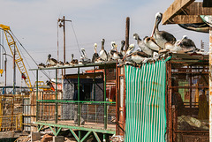
Pelicans (pelecanus thagus) waiting at at Arica harbour for fishing boats to come in. On the landward side sat a juvenile night heron.
Resting
| 20 Aug 2015 |
|
|
|
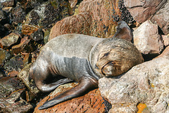
South American sea lion (Otaria flavescens) resting at Arica's fishing harbour
Arica
| 19 Aug 2015 |
|
|
|
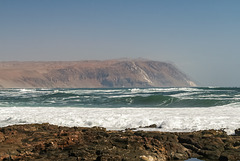
Pacific coast in the far north of Chile- seen from Alacrán peninsula at Arica.
Lluta Valley
| 17 Aug 2015 |
|
|
|
EXIF:
1/125 • f/9.0 • 18.0 mm • ISO 100/ Canon EOS 350D DIGITAL/ 18.0-200.0 mm
Lluta Valley seen from a hairpin bend on Ruta 11. This road leads from the port of Arica on the Pacific coast to the border with Bolivia at Lago Chungará, climbing more than 4500m in less than 200 km. Sadly the heavy traffic has lead to many fatal accidents over the years and the sight of roadside shrines/animitas is a common one.
Salar de Surire- view full size!
| 30 May 2015 |
|
|
|
Salar de Surire is situated at 4245m near the border to Bolivia. It is part of UNESCO's Lauca Biosphere Reserve and a Ramsar Wetland .
Nevertheless it is only listed as a Monumento Natural (the lowest level of protection) by the Chilean authorities because of Lithium mining.
EXIF: 1/160 • f/9.0 • 31.0 mm • ISO 100/ Canon EOS 350D/ 18.0-200.0 mm
stitched from 21 verticals
Jump to top
RSS feed- Gudrun's latest photos with "Arica y Parinacota" - Photos
- ipernity © 2007-2025
- Help & Contact
|
Club news
|
About ipernity
|
History |
ipernity Club & Prices |
Guide of good conduct
Donate | Group guidelines | Privacy policy | Terms of use | Statutes | In memoria -
Facebook
Twitter


