Jaap van 't Veen's photos with the keyword: Alpes
Switzerland - Muottas Muragl
| 20 Oct 2017 |
|
|
|
Muottas Muragl - on an altitude of 2.454 meters - is located high above the wide valley of the River Inn and the valley that leads to the Bernina Pass. It is without any doubt the most beautiful vantage point above the lakes, the villages of Upper Engadine and the surrounding mountains.
Between 1905 and 1907, the first funicular railway in Engadine was built here. Although modernised on many occasions, it has essentially remained the same to this day. The funicular railway takes over the 700-meter climb from Punt Muragl up to the Muottas Muragl in ten minutes. The upper section of the railway has sun collectors that cover the energy requirements of the mountain hotel/restaurant.
The mountain station is starting point of many hikes/walks. Among them is the well known Panorama Trail to Alp Languard, where one can take a chairlift to descend to the valley (PiP 2).
(The PiP was taken some minutes after the main picture.)
Switzerland - Bernina Pass
| 16 Oct 2017 |
|
|
|
The main picture is showing the Lago Bianco (see also PiP) and the road across the Bernina Pass before reaching the highest point. I took this picture from the Diavolezza cable car.
The Bernina Pass (2.328 m) is a mountain pass in the Bernina Range of the Alps. It connects the famous resort town of St. Moritz in the Upper Engadin valley with the Italian-speaking Val Poschiavo, which ends in the Italian town. Old paths crossed the Bernina Alps for hundred of years from Grisons to Valtellina in Italy. Back in 1865 a modern road replaced the old paths, which has been widened a number of times and has been open 365 days a year since 1965.
The Bernina Pass is also crossed by rail. The world famous Bernina Express has been travelling over the pass in summer since 1910 and since 1913 this popular tourist train is operating year-round between Chur and Tirano. It is the highest adhesion railway route in Europe. Energy source for the train line is the Lago Bianco, a hydro storage lake.
Switzerland - Säntis
| 28 Sep 2017 |
|
|
|
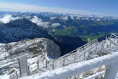
The Sántis is with a height of 2.502 metres the highest peak in the Alpstein massif in northeastern Switzerland. It is a natural landmark in the region between Lake Walen and Lake Constance. The mountain towers above one of the most beautiful landscapes of Europe and can be seen from miles away. .
The name Säntis dates back to the 9th century. It is an abbreviation of the Romansh language for Sambatinus (The one born on Saturday), which was thought to be the name of a nearby area. The name was later used to refer to the summit. In the German language it was originally called Semptis or Sämptis.
We were quite lucky with the weather during our visit. We took the aerial cable car at 9.30 am from Schwägalp, right at the foot of the Säntis At the peak we had a breathtaking clear 360-degree view, although it was freezing cold. It is said that one can see six Alpine countries: Switzerland, Germany, Austria, Liechtenstein, Italy and France. To be honest I can not tell if I saw all these countries. When back - just more than an hour later - the peak was already surrounded by clouds !!
Main picture: Swiss Alps with the Churfirsten in the ‘foreground’.
PiP 1: panorama (three pictures stitched together) looking north (Germany and Lake Constance) and northeast (Austria).
PiP 2 and 3: freezing and ‘hoarfrosting’ cold.
Jump to top
RSS feed- Jaap van 't Veen's latest photos with "Alpes" - Photos
- ipernity © 2007-2025
- Help & Contact
|
Club news
|
About ipernity
|
History |
ipernity Club & Prices |
Guide of good conduct
Donate | Group guidelines | Privacy policy | Terms of use | Statutes | In memoria -
Facebook
Twitter


