Jaap van 't Veen's photos with the keyword: Unesco World Heritage Site
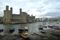
Wales - Caernarfon Castle
| 21 Sep 2017 |
|
|
|
Caernarfon Castle is probably the most impressive and famous of the many Welsh castles. The site of the castle wasn’t chosen by accident. It had previously been the location of a Norman motte and bailey castle and before that a Roman fort stood nearby.
King Edward I started the construction of the castle in 1283, being part of city walls of medieval Caernarfon. It was not only a military stronghold, but also a seat of government and a royal palace. Standing at the mouth of the Seiont river, the fortress with its towers, battlements and colour banded masonry still dominates the walled town, also founded by Edward I.
Edwards son was born in Caernarfon Castle. In 1301 he became the recreated title of Prince of Wales and it was the first time the eldest son of the King of England was invested as Prince of Wales.
In 1969 the castle gained worldwide fame as the setting for the investiture of Prince Charles as Prince of Wales.
In 1986, Caernarfon was added to the UNESCO list of World Heritage Sites as part of the "Castles and Town Walls of King Edward in Gwynedd
Wales - Pontcysyllte Aqueduct
| 12 May 2017 |
|
|
|
Pontcysyllte Aqueduct was built by Thomas Telford between 1795 and 1805. The aqueduct over the valley of the River Dee has 18 pillars; the highest ones come 38 meters above the water.
The Llangollen Canal runs over the aqueduct through a cast iron trough, which is more than 300 meters long, 3,7 meters wide and 1,6 meters deep; just enough for the narrow boats. Pontcysyllte Aqueduct is the longest and highest in Great Britain. The aqueduct carries a water passage for a single canal narrow boat as well as a towpath for pedestrians. It connects the Welsh villages of Froncysyllte and Trevor.
Pontcysyllte Aqueduct and the length of the Llangollen Canal from the Horseshoe Falls to Gledrid Bridge is now a World Heritage Site.
Australia – Uluru
| 21 Apr 2017 |
|
|
|
Uluru is considered being Australia’s best-known natural landmark. The huge ancient monolith is located in the (hot) heart of Australia’s “red centre” and is part of Uluru-Kata Tjuta National Park. Uluru is the Aboriginal and official name; it is also known as Ayers Rock, a name given in 1873 by William Gosse in honor of the Chief Secretary of South Australia, Sir Henry Ayers.
Uluru is an ancient landscape, rich in Australian indigenous culture and spirituality. The Aborigines of the area, who are known as the Anangu (traditional custodians of Uluru) believe this landscape was created by their ancestors at the beginning of time. They have been protecting these sacred lands ever since.
Uluru did arise about 600 million years ago; originally the rock sat on the bottom of a sea. Nowadays the highest point is about 348 meters above ground. The rock is 3.6 km’s long, 1.9 km’s wide and has a circumference of 9.4 km’s.
The surface is made up of valleys, ridges, caves and weird shapes that were created through erosion over millions of years. Surface oxidation of its iron content gives Uluru a striking orange-red hue.
Jump to top
RSS feed- Jaap van 't Veen's latest photos with "Unesco World Heritage Site" - Photos
- ipernity © 2007-2025
- Help & Contact
|
Club news
|
About ipernity
|
History |
ipernity Club & Prices |
Guide of good conduct
Donate | Group guidelines | Privacy policy | Terms of use | Statutes | In memoria -
Facebook
Twitter


