slgwv's photos with the keyword: Wallowa Mountains
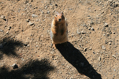
California ground squirrel
| 20 Sep 2019 |
|
|
Otospermophilus beecheyi , based on the white-spotted buff-gray coat. Hanging around the upper tram station on Mt. Howard, Wallowa Mountains, Oregon. Obviously his handout-getting technique has been working... ;)
California ground squirrel
| 20 Sep 2019 |
|
|
|
Otospermophilus beecheyi , based on the white-spotted buff-gray coat. Hanging around the upper tram station on Mt. Howard, Wallowa Mountains, Oregon. Obviously his handout-getting technique has been working... ;)
California ground squirrel
| 20 Sep 2019 |
|
|
Otospermophilus beecheyi , based on the white-spotted buff-gray coat. Hanging around the upper tram station on Mt. Howard, Wallowa Mountains, Oregon. Obviously his handout-getting technique has been working... ;)
California ground squirrel
| 20 Sep 2019 |
|
|
|
Otospermophilus beecheyi , based on the white-spotted buff-gray coat. Hanging around the upper tram station on Mt. Howard, Wallowa Mountains, Oregon. Obviously his handout-getting technique has been working... ;)
Well-fed
| 20 Sep 2019 |
|
|
|
One of a host of ground squirrels hanging around the upper tram station (where the bar and grill also are!) on Mt. Howard, Wallowa Mountains, Oregon. They are used to tourist handouts, as is obvious from their plumpness, and are disconcertingly tame. Most seem to be California ground squirrels ( Otospermophilus beecheyi ), based on the white-spotted gray coat, but there are also some golden-mantled ground squirrels ( Callospermophilus lateralis ), which are often confused with chipmunks due to their similar markings. The insets show some other views.
Moraine
| 20 Sep 2019 |
|
|
Lateral moraine along the east side of Wallowa Lake. Mt. Howard in the distance on the right.
Wallowa Lake
| 20 Sep 2019 |
|
|
|
From the boat ramp (visible to right) at the north end of the lake. The triangular mountain in the middle is actually the cross-sectional profile of the ridge separating the East (to the left) and West Forks of the Wallowa River. Mt. Howard, the location of the tramway, is on the left.
Wallowa Lake is a glacial lake, about 300 ft (90 m) deep in the middle, whose level has been raised slightly by a small outlet dam for water storage, as is common throughout the American west. A prominent lateral moraine extends along the east side of the lake. Its upstream end is visible at the extreme left; the inset shows a more extensive view.
Again, it's "wuhl-OW-uh," "OW" as in "town."
Wallowa Mountains
| 20 Sep 2019 |
|
|
|
Looking more westerly from near the summit of Mt. Howard (reached by the tram). Either The Matterhorn or Sacajawea Peak is the highest point in the range; the USGS Joseph 7.5' quad (1990 ed) shows Sacajawea Peak as slightly taller, but apparently other surveys disagree! Sacajawea Peak, of course, is named for the Native American woman who accompanied the Lewis & Clark expedition as a guide and interpreter. She is the only real historical woman, other than Susan B. Anthony, to appear on a circulating U.S. coin. Eagle Cap, the centerpiece of the eponymous wilderness area, is also outlined. The prominent canyon below the ridge with The Matterhorn and Sacajawea Peak holds the West Fork of the Wallowa River.
Again, it's wuhl-OW-uh, "ow" as in "town."
Wallowa Mountains
| 20 Sep 2019 |
|
|
|
Looking slightly west of south from off Mt. Howard, accessed by the Mt. Howard tramway. The Wallowas (wuhl-OW-uh, btw, with "ow" as in "town") lie in northeastern Oregon and don't fit the usual image of Oregon mountains. They're a heavily glaciated range in granitic and high-grade metamorphic rock, in contrast to the young volcanics of the Cascades. There was hardrock mining activity here in the late 19th and early 20th centuries, primarily for gold, but since the 1930s the bulk of the area has been preserved in the Eagle Cap Wilderness (previously "primitive area"), with Eagle Cap (outlined; 9572 ft/2918 m)) as the centerpiece. The East Fork of the Wallowa River lies in the prominent canyon below; the side drainage directly below the viewpoint is Royal Purple Canyon.
The Mt. Howard tramway rises some 4000 ft from the village at the base, and when built in 1970 was claimed to be the steepest tram in North America. Without it, views like this are not available without a long and strenuous climb! The inset shows a view more to the right, with the highest peaks marked.
The Wallowas are well known in the Pacific Northwest, but they're not much of a Destination otherwise. You don't even see that many California license plates in the campground! ;)
Jump to top
RSS feed- slgwv's latest photos with "Wallowa Mountains" - Photos
- ipernity © 2007-2025
- Help & Contact
|
Club news
|
About ipernity
|
History |
ipernity Club & Prices |
Guide of good conduct
Donate | Group guidelines | Privacy policy | Terms of use | Statutes | In memoria -
Facebook
Twitter


