RHH's photos with the keyword: bowtie arch
Bowtie Arch
| 02 Sep 2023 |
|
|
|
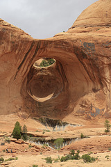
The photo shows the reason for the name of this arch, which can be seen outside of Arches National Park along the Corona Arch trail. The trailhead is along the Potash Road west of Moab, Utah.
This type of arch is called a pothole arch. It was formed when a pothole on the ledge above gradually merged with an alcove in the rock face below through the actions of water and debris. It is a fairly common type of arch.
Bowtie and Corona Arches
| 03 Jul 2023 |
|
|
|
The last day of our trip to Utah we hiked the Corona Arch trail west of Moab. The photo shows the two arches we saw, Bowtie Arch, a pothole arch, on the left, and Corona Arch, a free-standing arch, on on the right.
Bowtie Arch
| 03 Jul 2023 |
|
|
|
Bowtie Arch is along the Corona Arch trail west of Moab, Utah. We hiked the trail to both arches.
Bowtie Arch
| 12 Jun 2023 |
|
|
|
One of our last days in Utah we hiked the Corona Arch trail outside of Moab and off the Potash Road. The trail is not in any of the parks near Moab, but was a good hike, though the day was hot. Along the way to Corona Arrch we stopped at Bowtie Arch, a pothole arch in the cliffs above us. Pothole arches are formed by water in a pothole that eventually wears its way down to an opening in the cliff below.
Jump to top
RSS feed- RHH's latest photos with "bowtie arch" - Photos
- ipernity © 2007-2025
- Help & Contact
|
Club news
|
About ipernity
|
History |
ipernity Club & Prices |
Guide of good conduct
Donate | Group guidelines | Privacy policy | Terms of use | Statutes | In memoria -
Facebook
Twitter


