Scale distortion
I'm always interested in viewing landscapes in different ways.
For instance, next time you are out, try looking at the landscape with your head tilted on one side, so that your eyes are in a vertical alignment, instead of the horizontal we are so used to. Everything looks so different - notice especially the 'slot' between the earth and the cloud-base and how it recedes into the distance. Our wh… (read more)
For instance, next time you are out, try looking at the landscape with your head tilted on one side, so that your eyes are in a vertical alignment, instead of the horizontal we are so used to. Everything looks so different - notice especially the 'slot' between the earth and the cloud-base and how it recedes into the distance. Our wh… (read more)
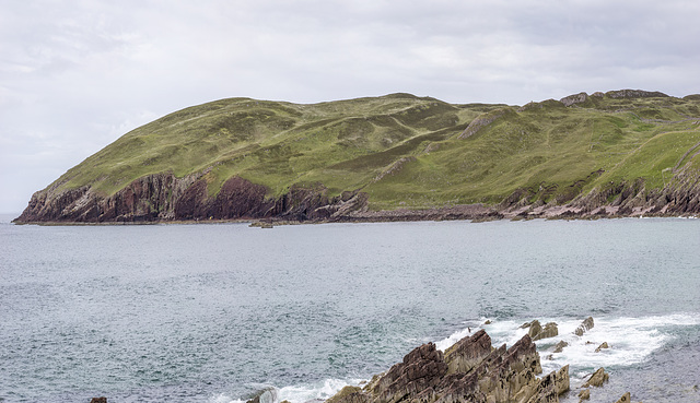
Bay of Stoer view NNW panorama x2 vertical exaggeration
View northwards over the Bay of Stoer from the Clachtoll broch An Dùn . Stac Fada (the rocky peninsula just left of centre) is the type locality for the Stac Fada Formation , recently interpreted as a meteorite impact debris horizon, comparable with suevite from the much younger Ries meteorite impact event in south Germany. The Stac Fada Formation lies within the Bay of Stoer Formation, mostly fluviatile sandstones and siltstones (Mesoproterozoic, c. 1200 Ma).
The vertical scale of the photo has been exaggerated by x2 in order to bring out the westerly (left) dipping bedding. A change in the magnitude and direction of dip above the Stac Fada Formation indicates the presence of a fault.
Kinderscout plateau from Higger Tor, x2 vertical exaggeration
View WNW from the north end of Higger Tor towards the Kinderscout plateau.
The x2 vertical exaggeration brings out the geological and geomorphological features in the landscape.
Hope Valley from Higger Tor 2; x2 vertical exaggeration
View westerly from the north end of Higger Tor towards Hope Valley, Mam Tor and Rushup Edge.
The x2 vertical exaggeration brings out the geological and geomorphological features in the landscape.
Burbage Valley from Higger Tor; x2 vertical exaggeration
The Burbage Valley and Burbage Edge viewed from Higger Tor.
The x2 vertical exaggeration brings out the geological and geomorphological features in the landscape. The break in the line of the gritstone edge just above the centre of the shot is due to a fault dislocating the Chatsworth Grit, downthrow to the north (left in the photo).
There has been extensive tree-felling here in the last couple of years, as can be seen in this and similar views. Here is the same plantation (from a different viewpoint) in 2007.
Stanage Edge south end from Burbage Edge; x2 vertical exaggeration
The southern end of Stanage Edge viewed from Burbage Edge. All the rocks in the photo are formed from the Chatsworth Grit (Namurian). The foreground rocks at the northern end of the Burbage Valley are at a lower elevation because of a fault between there and Stanage Edge.
The x2 vertical exaggeration helps bring out the geological and geomorphological features.
Carl Wark and Higger Tor from Burbage Edge; x2 vertical exaggeration
The Burbage Valley with Carl Wark and Higger Tor viewed from Burbage Edge.
The x2 vertical exaggeration brings out the geological and geomorphological features in the landscape.
Carl Wark and Higger Tor panorama; x2 vertical exaggeration
The Burbage Valley with Carl Wark and Higger Tor viewed from Burbage Edge. The rocks are comprised of the Chatsworth Grit (Namurian). The photo is composed from five portrait-style images stitched together using Photoshop automatic panorama software.
The x2 vertical exaggeration brings out the geological and geomorphological features in the landscape.
Millstone Edge panoramic, x2 vertical exaggeration
Eyam Moor is a good location to view the gritstone edges to the east of the Derwent Valley - from High Neb on Stanage Edge in the north down to Baslow Edge in the south.
All the main edges visible in this photo are comprised of a single gritstone unit - the Chatsworth Grit (a.k.a Rivelin Grit) in the 'Millstone Grit' group (Namurian).
Faulting has fractured the gritstone into discrete 'slabs' each with it's own elevation and dip direction. This accounts for the different sections of the edges - e.g. Higger Tor, Millstone Edge, Burbage Edge, etc.
This photo is comprised of 10 portrait-style photos joined together using Canon's 'Photostitch software, with some subsequent Photoshop cloning of the sky portion of the photo in order to give sufficient sky coverage along the length of the panorama.
The vertical scale has been exaggerated x 2 in order to bring out the various faulted sections of the gritstone edges.
The visible features L-R are:
Higger Tor, Millstone Edge (part-quarried), Millstone Edge (eastern part - upfaulted, with the gritstone tors of Over Owler Tor and Mother Cap Stone) and Burbage Edge, southern part.
Lewes structure
A screen-shot from a computer model which I constructed as part of my work a few years ago. It shows the geological structure of the eastern part of the South Downs in Sussex. The view is looking from W to E; north is on the left side of the photo, south on the right. The vertical scale is exaggerated 4 times.
Jump to top
RSS feed- Latest items - Subscribe to the latest items added to this album
- ipernity © 2007-2025
- Help & Contact
|
Club news
|
About ipernity
|
History |
ipernity Club & Prices |
Guide of good conduct
Donate | Group guidelines | Privacy policy | Terms of use | Statutes | In memoria -
Facebook
Twitter


