Shooting information for this photo
← Back to the photo page
Want to know more about EXIF?
Check wikipedia page about Exchangeable image file format (EXIF)
Check wikipedia page about Exchangeable image file format (EXIF)
Some of EXIF data are only available in English.
| Camera: | Apple iPhone 7 |
|---|---|
| Exposure: | 0.00015 sec. (1/6849) |
| Aperture: | f/1.8 |
| Focal Length: | 4.0 mm (35 mm equivalent: 28.0 mm) |
| Flash: | Off, Did not fire |
| Exposure mode: | Program AE |
| Resolution: | 72 x 72 dpi |
| Dimension: | 4032 x 3024 pixels |
| Original Date: | 2022:05:26 07:50:18.538 |
| Digitized Date: | 2022:05:26 07:50:18+02:00 |
| Created on: | 2022:05:26 07:50:18.538 |
| Modified on: | 2022:05:26 07:50:18 |
| Software: | GIMP 2.10.24 |
| Copyright: | Matthias Köhler |
| Api | 2.0 |
| Artist | Matthias Köhler |
| Brightness Value | 11.88757513 |
| Caption Writer | Matthias Köhler |
| Circle Of Confusion | 0.004 mm |
| City | Starzach |
| Components Configuration | Y, Cb, Cr, - |
| Compression | JPEG (old-style) |
| Country | Deutschland |
| Country Code | DEU |
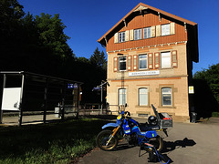
| Description | Obere Neckarbahn - Bahnhof Bieringen |
| Exif Version | 0232 |
| Exposure Compensation | 0 |
| Exposure Mode | Auto |
| Field Of View | 65.5 deg |
| Flashpix Version | 0100 |
| Focal Length In 35mm Format | 28 mm |
| Format | image/jpeg |
| History Action | saved |
| History Changed | / |
| History Instance ID | xmp.iid:a7a69c27-fb0d-401f-b8f 6-26028d4f95fa |
| History Software Agent | Gimp 2.10 (Windows) |
| History When | 2022:05:26 10:08:50 |
| Host Computer | iPhone 7 |
| Hyperfocal Distance | 2.07 m |
| ISO | 20 |
| Image Description | Obere Neckarbahn - Bahnhof Bieringen |
| Image Size | 4032x3024 |
| Lens Info | 3.99000001mm f/1.8 |
| Lens Make | Apple |
| Lens Model | iPhone 7 back camera 3.99mm f/1.8 |
| Light Value | 16.8 |
| Location | Bieringen |
| Metering Mode | Spot |
| Original Document ID | xmp.did:8e1c1b0b-5ab7-405f-a57 f-aaa59b72e13a |
| Photometric Interpretation | YCbCr |
| Platform | Windows |
| Rating | 5 |
| Rating Percent | 99 |
| Resolution Unit | inches |
| Rights | Matthias Köhler |
| Samples Per Pixel | 3 |
| Scale Factor To 35 mm Equivalent | 7.0 |
| Scene Capture Type | Standard |
| Scene Type | Directly photographed |
| Sensing Method | One-chip color area |
| State | Baden-Württemberg |
| Sub Sec Time Digitized | 538 |
| Sub Sec Time Original | 538 |
| Subject Area | 2863 1239 753 756 |
| Thumbnail Offset | 2588 |
| Time Stamp | 1653552530194028 |
| Version | 2.10.24 |
| White Balance | Auto |
| XMP Toolkit | Image::ExifTool 10.96 |
| Y Cb Cr Positioning | Centered |
GPS Information |
|
| GPS Altitude | 364 m Above Sea Level |
| GPS Altitude Ref | Above Sea Level |
| GPS Date Stamp | 2022:05:26 |
| GPS Date/Time | 2022:05:26 00:00:00Z |
| GPS Dest Bearing | 233.3811341 |
| GPS Dest Bearing Ref | True North |
| GPS Horizontal Positioning Error | 52976/6621 m |
| GPS Img Direction | 233.38 |
| GPS Img Direction Ref | True North |
| GPS Latitude | 48 deg 26' 56.89" N |
| GPS Latitude Ref | North |
| GPS Longitude | 8 deg 51' 39.85" E |
| GPS Longitude Ref | East |
| GPS Map Datum | WGS-84 |
| GPS Position | 48 deg 26' 56.89" N, 8 deg 51' 39.85" E |
| GPS Speed | 0.06286095083 |
| GPS Speed Ref | km/h |
| GPS Version ID | 2.2.0.0 |
Jump to top
- ipernity © 2007-2025
- Help & Contact
|
Club news
|
About ipernity
|
History |
ipernity Club & Prices |
Guide of good conduct
Donate | Group guidelines | Privacy policy | Terms of use | Statutes | In memoria -
Facebook
Twitter
